A Brief History of the Hanney Villages
People have been living in and around Hanney for at least 5,000 years. Recent archaeology, much of it undertaken in advance of proposed developments, has added greatly to our knowledge of early occupation in the area with Neolithic pottery, and Bronze Age and Iron age settlements. During the Roman occupation there was a lot of activity with a small settlement to the south of Summertown and a Roman road, possibly on the route of the A338, from Wantage to the religious site at Frilford and beyond to Alchester.
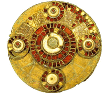
Two major metal detector rallies in 2009 and 2010 on fields to the south and west of the villages found a small number of Bronze Age items, rather more from the Iron Age and a wealth from the Roman period. However, the most important find was of a 7th century Anglo-Saxon gold and garnet brooch which has become known as the Hanney Brooch and is the logo for Hanney News.
The earliest written records of the area are from Saxon royal charters. One dated 968 A.D describes the gift of land to Abingdon Abbey by King Edgar. The boundaries within it almost entirely correspond to the present parish boundaries of East Hanney. Although no similar charter exists for West Hanney the Church of St. James the Great is thought to be of Saxon origins and to have been an early minster church, from which priests were sent out to other settlements.
The Domesday Survey of 1086, by which time the villages were part of Berkshire, records that the land was held by Norman overlords and by Abingdon Abbey and also by the priest, Turold. The Norman owners went on to give the land to the religious communities they were endowing. The various manors therefore were mainly managed from afar with regular manor courts being held to review or endorse landholdings. Day to day village life was organised by the small yeoman farmers who held the land.
West Hanney was always the “senior partner”, the township of East Hanney and the tithings of North Denchworth and Philberds being part of that ecclesiastical parish. North Denchworth and the settlement of Philberds have more or less disappeared but North Denchworth was at one time the residence of the Fettiplace family and Philberds had its own “free chapple” first recorded in 1260. The site of the chapel is uncertain but it is likely to be near Poughley farm where in 1732 the farmer was allowed to “clear Chapple Close of stones and plough it in”. The Manor of Philberds is a sort of “buffer state” between East and West Hanney comprising the land between the Letcombe Brook and the old green track or “Cow Lane”. At an early stage this land was enclosed whereas East and West Hanney remained mainly cultivated in common in long strips in the furlongs which divided the large open fields until the enclosures of the nineteenth century. Consequently, the old enclosed land shows evidence of medieval ploughing “fossilised” when the arable fields were enclosed and used as pasture. The green lane to the north of the school was once a well-used roadway ditched on both sides and the headlands of the fields where the oxen used to turn the ploughs can be seen abutting it. In 1776 the trustees of the new turnpike (now the A338) sold the northern part of the lane to a local farmer.
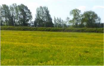
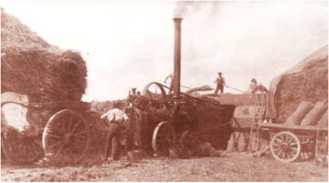
The villages have always had a good deal of fertile arable land with much prized meadowlands along the Letcombe and Childrey Brooks. The names of some of these meadows – Broad Dole, Butterwell, Pen End and Lossall are redolent of cattle knee deep in buttercups in a rural idyll, however this often belies the harsh reality of rural life. A Government Commission in the 1880s heard from a ploughboy whose day began at 5a.m. In all weathers he would often have to walk his horses to the far end of the parish to begin his long working day, which could not have changed much over the centuries. As agricultural fortunes plunged in the late nineteenth century, farmers turned to producing fruit, which could be sent to London and other cities on the newly created Great Western Railway from nearby Grove Road Station. Walking around the villages you will still see a few of the remaining orchards and some of the walnut trees, which were also a feature of the area.
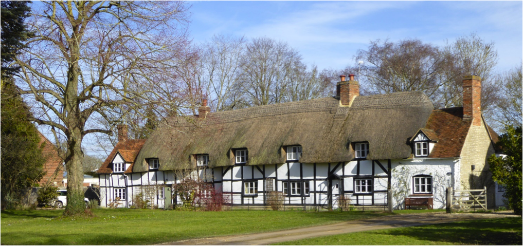
The villages themselves follow the better-drained higher land, the “ey” in Hanney indicating the origin of the present settlements as islands in the Vale. There must have been successions of houses built on the old farmhouse sites. Initially, easily available materials were used – timber, thatch and wattle and daub made from mud and animal hair, but as life became more prosperous and building techniques advanced stone was used to make more solid foundations and brick and tile from local producers were introduced. The coming of the Wilts and North Berks Canal in 1810 brought more mass-produced bricks and slates to the area so gradually many differing buildings grew into the picture we see today.
The Hanneys were mainly villages of independent copyhold and tenant farmers and, walking about, it is easy to identify some of their old farms with modern ‘infilling’ of their orchards and yards and conversion of their farm buildings. At present both of the villages are growing in size but this has not always been the case. At the end of both Snuggs Lane and Ebbs Lane in East Hanney there is evidence of medieval shrinkage. The villages appear to have been badly affected by the Black Death in the 1340s and in the late nineteenth and twentieth centuries many of the “picturesque” cottages were lost as villagers moved out to the towns in search of work and landlords failed to maintain the buildings.
Until relatively recently the villages were fully self-sufficient sustaining many tradesmen, craftsmen, several shops, bakers and pubs. The last baker and the shops in both East and West Hanney closed in 1988 and a community shop run by volunteers and housing the Post Office was created in their place. The village craftsmen – carpenters, leather workers, blacksmiths and wheelwrights have today been replaced by many other “homeworkers” but their work is usually of a less manual nature.
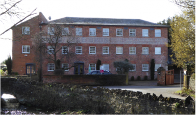
Water has always played an important part in the community economy. In walking around the villages it is worth noticing the causeways which keep you out of the wet. Until very recently East and West Hanney used to be regularly cut off from each other in wet weather. The Letcombe Brook has been the site of several mills, the two remaining being Dandridge’s Mill and West’s Mill (Lower Mill) further downstream. The present Dandridge’s Mill was built as a silk mill in 1820 and church records show the death of an 8-year-old child in its machinery in the 1830s. West’s Mill was badly burnt out by a fire in 1906, the Wantage Fire Brigade being unable to get here quickly enough to save it.
As you walk around the villages there are several buildings worth noting. A special stop should be made at the church in West Hanney dedicated to St James the Great to admire the magnificent Norman inner doorway and the lovely font with its delicately incised carving. The brasses in front of the altar are especially fine showing clearly some of the grander folk who used to live in the area.
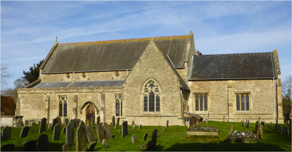
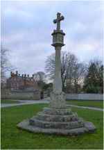
To some it was a healthy place to live – notice the plaque on the wall at the back of the church to Elizabeth Bowles who died at the age of 124. On her marriage her husband brought her home to Hanney in a cart drawn by a team of twelve snow-white oxen. Outside the church the graveyard rises up on either side showing the centuries of burials of unknown Hanney residents. Ahead lies one of the village causeways. To the west of the graveyard is Prior’s Court, a fine Jacobean farmhouse which belonged for six centuries to New College, Oxford where our village records can still be found. Across the road behind the high brick wall is the elegant William and Mary façade of West Hanney House, formerly Rectory Farm and once belonging to the Diocese of Salisbury. Across the causeway to the east is the old Vicarage with its Georgian brick frontage and tucked away behind it is Church Farm, now a private house with new, barn style, houses in the farmyard. On the east of the churchyard is The Old Post Office, now called The Dower House, a very fine close-timbered medieval building said to have belonged to the Yate family. The village green, with its cross in the middle, has been enclosed upon and shrunken, it used to stretch from the church to the far end of North Green. The old blacksmith’s forge burnt out in another fire is now the site of a modern house.
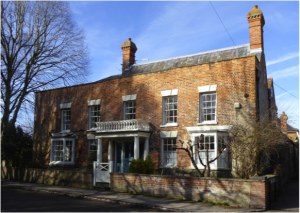
East Hanney also has its share of handsome buildings including The Mulberries, one-time home of James Robins Holmes, and Philberds Manor, previously known as Day’s House, tucked away by the brook in a timeless setting. The former church of St James the Less was designed by the well-known Victorian architect, G.E Street and was closed for services in 1976, it is now a private house.
Mr Holmes recognised the attractiveness of old cottages. Before his death in 1937 he had acquired many of them, keeping them in good order and letting them out at low rents. The result is that they are still with us today. Other cottages which were overcrowded, unhealthy and damp with no modern amenities were pulled down and ultimately replaced in the 20th century by council houses or modern developments.
James Holmes also felt that residents responded to pleasant surroundings. He made sure that there were agreeable walks along the Brook and planted trees and flowers. He introduced a village bathing place on the brook, just for men and boys, even the residents of West Hanney were allowed to come!
East and West Hanney had traditionally been rivals. Fortunately, today joint enterprises supported by both parishes such as the village school and the village hall bring both villages together and we all share a wide range of clubs and societies and work jointly on maintaining the Letcombe Brook and the Community Woodland and enjoy the Michaelmas Fayre.
If you would like more information on the history of the Hanneys contact the Hanney History Group.